How to Measure Area from an Image: Photos and Screenshots of Plans and Maps
Published by @SoNiceInfo at 11/3/2026
Whether it is a phone photo of a paper drawing, a screenshot of a PDF, or a floor plan from a listing, you can measure area from an image as long as one thing in it has a known length to set the scale. The easiest way is to load the image into Drawing Measure, a free tool that runs in your browser, and click around the area. For land, a map's own measuring tool is better; for microscope and other scientific images, ImageJ. This article measures a room on a sample floor plan image, compares four methods, and covers how to photograph a drawing and where the errors come from.
The four methods compared
Getting an area from an image needs a scale to turn lengths in the image into real lengths. The methods differ in how they get that scale and what kind of image they suit.
| Method | Best for | Scale from | Uploads the image | Effort |
|---|---|---|---|---|
| Drawing Measure (recommended) | Images and photos of drawings and plans | A dimension or scale bar | No (on your device) | Low |
| Google Earth | Land, on the map | Not needed (map coordinates) | No image used | Low |
| ImageJ | Microscope and other scientific images | A line of known length | No (desktop app) | Install needed |
| Counting a grid | A printed image | The grid size | No | High |
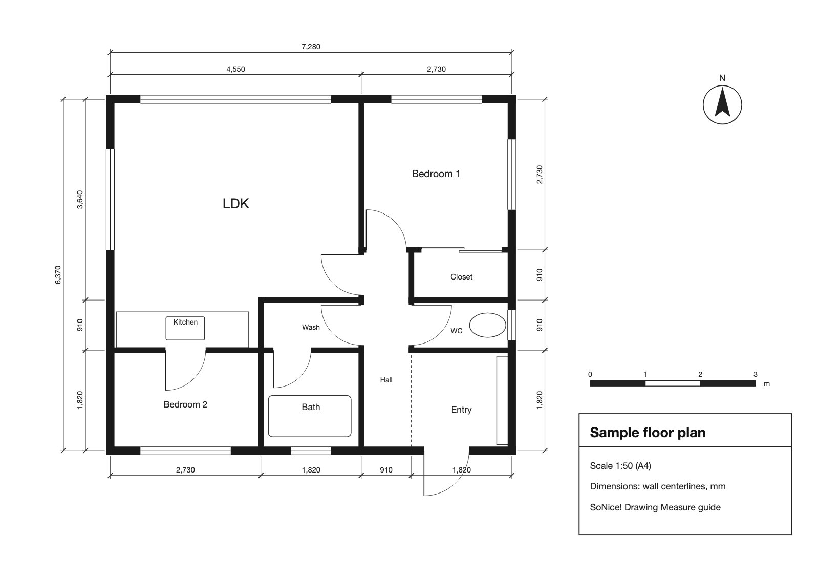
This article measures the L-shaped LDK on a sample floor plan (1:50, dimensions to wall centerlines in mm) saved as a 1600-pixel-wide JPEG. Download the sample image (JPEG) to follow along.
RecommendedMethod 1: Set the scale and outline it in Drawing Measure
Drawing Measure is a free web tool that measures lengths, floor areas, and wall areas on PDF and image drawings (made by the author of this article). It runs in your browser, and the image you load is processed on your device without being uploaded to a server.
Load the image
Drag and drop a JPEG, PNG, or other image. Phone photos work as they are.
Set the scale from a known length
Type in the length of a dimension or scale bar and click both of its ends.
Click around the area
Click the corners in order to get the area.
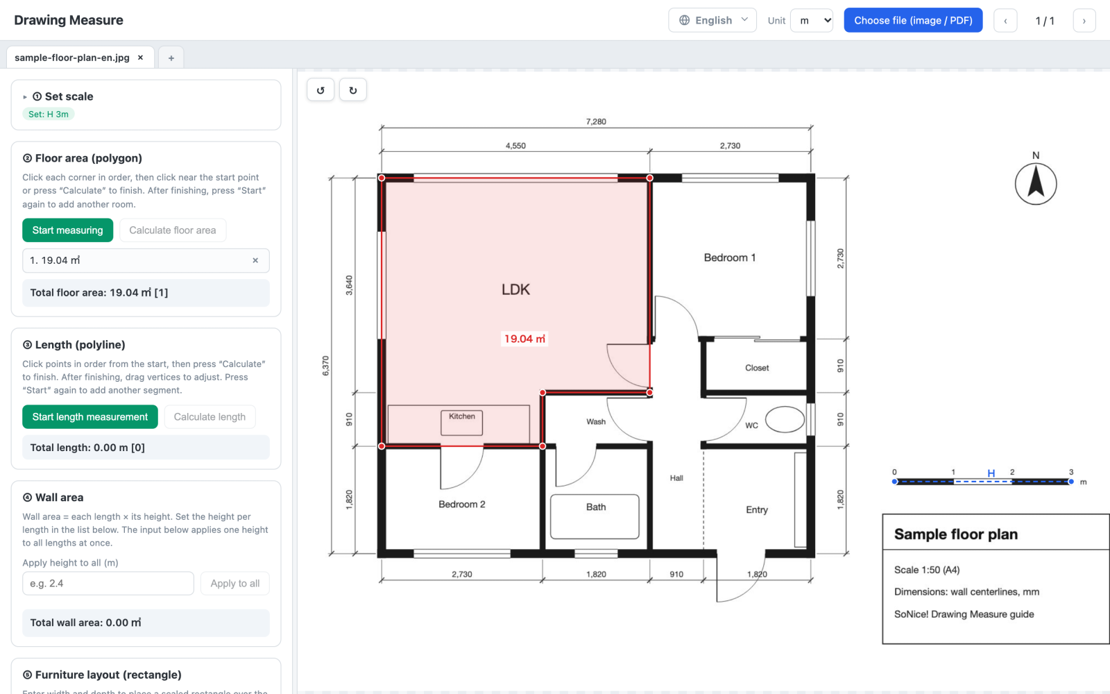
- Open Drawing Measure and click "Choose file" or drop the image onto the page. Set "Unit" at the top to m (or ft for plans in feet).
- In "Set scale", enter the reference length as the horizontal scale. The sample uses the scale bar on the right (0 to 3 m), so enter 3.
- Click "Set horizontal" and click both ends of the scale bar. Zooming in first makes the clicks more accurate.
- Under "Floor area", click "Start measuring", click the corners of the room in order, and click the start point again.
On the sample image, the LDK comes out at 19.04 m² (about 205 ft²). Loading the same plan as a PDF and setting the scale from the 7,280 mm overall dimension gives 19.05 m², so the difference is under 0.1%. The small error comes from the shorter reference (the 3 m bar instead of the overall dimension) and the image's lower resolution than the PDF. If the image has a long written dimension, use that as the reference for a smaller error.
Areas cut off at the edge of the image, or on another sheet, can't be measured. Several images can be open at once in tabs.
Free · No sign-up · Processed on your device
For landMethod 2: For land, measure on the map in Google Earth
For the rough area of a lot or a field, measure directly on the map. Google Earth has a measuring tool that needs no scale setting.
- Open Google Earth on the web and find the place you want to measure.
- Click Measure. The view switches to top-down.
- Click the corners of the area in order, then click the first point again to close the shape. The area and perimeter appear in the panel.
Google's help page, Measure distances and areas in Google Earth, has the details; it notes that measurements don't account for changes in elevation. Treat map measurements as estimates. Sales and records use the area on the deed or the survey.
For scientific imagesMethod 3: For scientific images, ImageJ
ImageJ is free image analysis software developed at the US National Institutes of Health (NIH), for Windows, Mac, and Linux. It is widely used to measure research images, such as cells in microscope photos or the area of leaves.
- Open the image and draw a straight line over something of known length, such as a scale bar.
- Choose Analyze → Set Scale…, enter the real length as "Known distance" and the unit as "Unit of length", and click OK.
- Outline the area with a polygon or other selection tool and choose Analyze → Measure to get the area.
It can also select regions by color or threshold and measure complex shapes automatically. Since it needs an install and its own learning curve, Method 1 is quicker for measuring rooms on a plan.
No tools at handMethod 4: Count a grid
Print the image, lay graph paper or a transparent grid over it, and count the squares inside the area. Count the squares fully inside, add half of each square cut by the boundary, and you have an approximate area.
The real area of one square comes from the scale. A 1 cm grid on a 1:100 plan makes each square 1 m × 1 m = 1 m²; a 1/4 in grid on a 1/4 in = 1 ft plan makes each square 1 sq ft. No arithmetic is needed for odd shapes, but finer grids take longer to count, and a print at the wrong size changes the scale (see printing at another size).
What to use as the scale reference
Whether you can get an area from an image depends on whether something in it has a known real length.
- A dimension written on the drawing: the most reliable. Choose the longest one, such as an overall dimension.
- A scale bar: the graduated bar on drawings and maps. It shrinks and grows with the image, so it still works after resizing.
- A length you measured in person: a door or one wall of the room, measured on site.
A stated scale such as "1:100" is not enough on its own, because an image's size in pixels depends on how it was saved and displayed. For the arithmetic behind scales, see How to Calculate the Scale of a Drawing.
Photographing a drawing, and where errors come from
When you photograph a paper drawing with a phone, how you take the photo matters more than anything else.
- Shoot straight down: an angled shot turns the drawing into a trapezoid, so the scale differs between near and far. The web tool can't fix that afterwards. If you work from paper drawings a lot, the Zumen app for iPhone and iPad captures them with the camera and straightens them by matching the four corners.
- Flatten the paper: folds and curling also shift lengths.
- Keep the area near the center: lens distortion is strongest at the edges. For a large drawing, photograph it in parts.
- Set horizontal and vertical scales separately: for faxes or scans with a stretched aspect ratio, Drawing Measure can set each direction from its own dimension.
- Use the PDF if you have it: a screenshot is limited to your screen's resolution. Loading the original PDF lets you measure more finely.
Which method is right for you
- You have a photo or image of a drawing or floor plan: Drawing Measure. Set the scale from a dimension or scale bar and click the corners.
- You want the rough area of land: Google Earth. Outline it on the map without setting a scale.
- You are measuring scientific images: ImageJ, which can select regions automatically by color.
- You'd rather not use a computer or phone: count a grid.
FAQ
Q. Is there a free app that measures area from a photo or image?
Drawing Measure runs in your browser. Load a JPEG or PNG, set the scale from something of known length in the image (a dimension or a scale bar), then click the corners of the area to get its size. It is free, needs no sign-up, and processes the image inside your browser without uploading it. It also works in phone and tablet browsers.
Q. Can I measure area in an image with no scale?
Yes, if one thing in the image has a known length: a written dimension, a scale bar, or something you measured in person. Set the scale from it. If nothing in the image has a known length, you can't get an accurate area.
Q. Can I measure from a photo taken at an angle?
Not in the web tool. Shooting at an angle turns the drawing into a trapezoid, so the scale changes across the image. Separate horizontal and vertical scales fix a stretched aspect ratio, but not that keystone distortion. Retake the photo straight on, or use a scanner. The Zumen app for iPhone and iPad can straighten an angled photo by matching its four corners.
Q. How do I measure the area of land on a map?
In Google Earth on the web, click Measure, click the corners of the area, and click the first point again to close the shape; the area and perimeter appear in the panel. Map measurements are estimates and may not match the area on a deed or a survey.
Q. Is it safe to upload a floor plan image to an online tool?
Some online measuring tools send your image to their server. Plans and drawings can include addresses and building details, so check the terms and where the image goes. Drawing Measure does not upload the image; it is processed on your device.
Q. What if a listing's floor plan image has no dimensions?
Room labels alone aren't a reliable scale. Ask the agent or owner for a dimensioned plan, or measure one length on site and use it as the reference. A standard-looking door is only a rough reference, since door widths vary.
Summary
To measure area from an image, set the scale from something in it with a known length, such as a dimension or a scale bar. In Drawing Measure, load the image, set the scale, and click the corners. For land, Google Earth's Measure tool is simpler; for scientific images, ImageJ. Photograph drawings straight on and use the longest reference you can for the smallest error.